Hampshire County Council have asked the public for their comments on the improvements needed to allow us to walk and cycle locally.
This is a very important process that identifies improvements needed to crossings, pavements, junctions and cycleways to allow us to move around safety on foot and by bike in a pleasant and safe manner.
The intention is that in the future, if and when funding becomes available, there will be a list of infrastructure upgrades ready for investment.
It would be fantastic if as many PeCAN supporters as possible could please respond to the consultation by 17th November, to stress the importance of being able to safely and conveniently walk and cycle locally.
Find the online consultation here.
The quickest way to respond is to use the Map Base Survey section within the online consultation. Find it here. This part of the survey can be used to highlight the specific sites which cause you problems with your local walking and cycling trips. This could be anything, from unsafe crossings to junctions that scare you when cycling or put you off cycling.
Full details of Hampshire County Council’s proposed improvements can be found in their LCWIP (normally pronounced l-c-whip) document, which stands for Local Cycling and Walking Improvement Plan.

Proposed Cycle Network
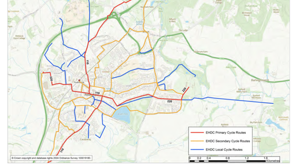
From the cycle network overview map, this map details the cycle network for Petersfield.
Primary, secondary and local cycle routes have been identified - primary in red, secondary in yellow, local in blue.
Primary routes represent busy, direct and main routes; secondary represent medium usage routes through local areas and feed into the primary routes. Local routes cater for local cycle trips and often provide links to primary or secondary routes.
This map is from LCWIP consultation - map page 16.

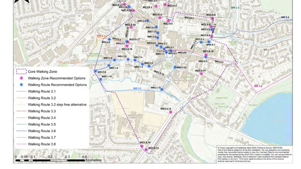
Proposed Core Walking Zone
Transport planners talk about “core walking zones” which are areas containing popular destinations such as supermarkets or a station, hence the town centre focus. Core walking zones are normally about a five-minute walking radius from the centre (approximately 400m). The core walking zone defined in Petersfield is shown here, see LCWIP consultation - map page 131.
In addition, a number of priority walking routes have been defined and audited to see where improvement should be made. These routes allow residents to walk to local schools, to the town centre, and so forth.
Comments about these routes can be submitted by the Map Based Survey. Alternatively, email comments to [email protected] or write to:
Insight & Engagement Unit, Hampshire County Council, Elizabeth II Court South, The Castle, Winchester, SO23 8UL
Have your say before the consultation closes on the 17th of November!
In June 2019, Hampshire County Council declared a Climate Emergency, joining more than 70 local authorities across the country in committing to put environmental issues at the heart of everything it does. With around a third of carbon emissions in Great Britain coming from road transport, this LCWIP supports important mitigation and adaptation to climate change, including targets for carbon neutrality.
Shortly after East Hampshire District Council declared their climate emergency in July 2019 and adopted a wide-ranging Climate and Environment Strategy in August 2020. East Hampshire District Council recently adopted the refreshed Climate and Environment Strategy, in July 2024.
